
Today I kicked off my #Summer2025microadventures challenge and had an unexpected pre-microadventure embedded in my planned microadventure!
What’s the summer 2025 microadventures challenge? I’ve decided to find and document 20 microadventures over the next 5 months. A microadventure is a local, small-scale adventure that involves exploring, learning and pushing your boundaries just a bit. You can read more about it in the blog post I linked above.
Through the Ottawa Valley Spinners and Weavers Guild, I had been in contact with Shirley who had an inexpensive used tapestry frame loom for sale. She lives on Ault Island near Upper Canada Village, so I thought I’d combine the errand to head out to pick up the frame loom with a chance to do something I’ve wanted to do for years: explore the spots where you can see the remains of the old Highway 2 that was flooded in the 1950s when they created the St Lawrence Seaway.
I thought my visit to Shirley’s weaving studio would be a quick pick-up, but we had so much fun chatting that I was there an hour before I managed to tear myself away. Shirley and her sweet rescue pup Maggie are living my dream life with a sun-filled studio space in her home that has a window looking out onto the blue waters of the St Lawrence river. I may have been more than a little covetous. When I told Shirley about my plan to explore the remaining bits of the old flooded highway, she mentioned that one of her neighbours has an asphalt patch of the old highway right at the end of their property, and she told me where to watch on the causeway back toward the mainland to see the flooded area where the old railway track used to lie. By the time I left, I’d been introduced to her amazing 12-shaft loom, had a tour of the studio, talked a lot of fibre talk, learned a bit about the history of the area, picked up tips on where I can put in my kayak to explore the next time I come out AND picked up the tapestry weaving frame loom I’d come to collect. All that before I even started my microadventure!
My planned microadventure was to explore the places where you can still see remnants of the old Highway 2 on the islands along the Long Sault Parkway. I’ve long been fascinated by the history of the Lost Villages in the area. Have you heard about the Lost Villages? In 1958, to facilitate the creation of the St Lawrence Seaway and a new hydroelectric dam, many acres of farmland and 10 villages were flooded. Many of the homes, barns and community buildings were relocated, but much of the original infrastructure is still visible underneath the surface of the river.
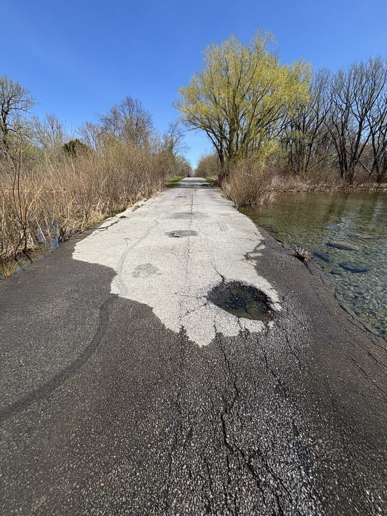
Exploring Highway 2 and the Lost Villages
In the summer of 2022, we kayaked in seasonally low water over the remains of the lost village of Wales.
Today, I wanted to check out the visible remains of the original Highway 2. You can trace the straight path of the original highway just to the south of the Long Sault Parkway as it drifts on and off what are now islands and what used to be high points on rolling riverside agricultural land. The highway runs from the east side of Macdonnell Island, slipping on and off the south part of the island, and then touching Philpotts Island and the southmost tip of Vankoughnet Island.

My first stop was Macdonnell island. I investigated both sides of the stub of the highway on either side of the little “bite” the river takes out of the highway. I may have gotten well entangled in a curlicued nest of grapevines.


I got back in the car and moved to the southeast tip of Macdonnell Island. From there, you can see the old highway heading out to tiny Royal Baker Island.

It was a perfect spring morning to be exploring. The Long Sault Parkway has only just opened for the season, so I saw almost no other cars. If you plan to park or camp anywhere off the parkway you need a permit, but for my 15 minute stops to explore and take photos, I seemed to be fine. I would expect otherwise in the high season.
My final stop was back in the direction I’d come, on Philpotts Island. This is once again looking west, the most westerly spot of the old highway that I could find.


This was the perfect way to start my Summer 2025 Microadventures challenge! I have wanted to check out these spots where the old Highway 2 disappears under the St Lawrence River for years. In doing a bit of research, I learned more about the Lost Villages and actually seeing the old road helped me visualize a bit of what it must have been like in the 1950s when they started flooding. Really, it only piqued my curiosity to learn more about this somewhat unknown part of local history.
Now, what’s the plan for the next microadventure?